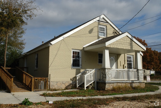
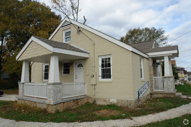
Property Record
1719 Candler Rd, Decatur, GA 30032

NEARBY LISTINGS FOR SALE OR LEASE
Property Detail
1719 Candler Rd
Atlanta-Sandy Springs-Roswell, GA
East Lake Estates
15-183-05-009
TRACT 15-AUG-05 .14AC 41 X 7 X 136 X 50 X 144
Officebuilding
DeKalb
X
Georgia
13089C0131J
10
2025
0.14 AC
2025
I-20 East/Conyers
023101
Atlanta
1,023 SF
DEMOGRAPHICS near 1719 Candler Rd
1 Mile
3 Mile
5 Mile
2024 Total Population
10,342
106,723
288,932
2029 Population
10,452
107,151
291,590
Pop Growth 2024-2029
+ 1.06%
+ 0.40%
+ 0.92%
Average Age
41
40
39
2024 Total Households
4,349
44,907
123,115
HH Growth 2024-2029
+ 1.06%
+ 0.48%
+ 1.12%
Median Household Inc
$76,917
$71,397
$76,781
Avg Household Size
2.30
2.30
2.20
2024 Avg HH Vehicles
2.00
2.00
2.00
Median Home Value
$362,682
$379,911
$376,424
Median Year Built
1958
1966
1974
Nearby Places
Map Layers
Map Styles
 Street
 Aerial
- Restaurants
- Banks
- Shops
- Fitness
- Groceries
PUBLIC TRANSPORTATION
AIRPORT
Hartsfield - Jackson Atlanta International
DRIVE
WALK
Distance
Hartsfield - Jackson Atlanta International
25 min
15.0 mi
Nearby Properties
Address
Land Use
TOTAL SIZE
Lot Size
Zoning
Address
Land Use
TOTAL SIZE
Lot Size
Zoning
123,732 SF
0.51 AC
RM75
Address
Land Use
TOTAL SIZE
Lot Size
Zoning
327,098 SF
4.92 AC
X
Address
Land Use
TOTAL SIZE
Lot Size
Zoning
99,770 SF
2.14 AC
Address
Land Use
TOTAL SIZE
Lot Size
Zoning
290,130 SF
6.13 AC
R100
Address
Land Use
TOTAL SIZE
Lot Size
Zoning
67,882 SF
4.77 AC
X
Address
Land Use
TOTAL SIZE
Lot Size
Zoning
350,556 SF
46.09 AC
X
Address
Land Use
TOTAL SIZE
Lot Size
Zoning
244,293 SF
2.09 AC
C-2
Address
Land Use
TOTAL SIZE
Lot Size
Zoning
298,763 SF
3.27 AC
M
Address
Land Use
TOTAL SIZE
Lot Size
Zoning
104,501 SF
2.56 AC
X
Address
Land Use
TOTAL SIZE
Lot Size
Zoning
81,129 SF
4.29 AC
C1
Address
Land Use
TOTAL SIZE
Lot Size
Zoning
76,654 SF
3.14 AC
C-1
Address
Land Use
TOTAL SIZE
Lot Size
Zoning
93,584 SF
0.66 AC
X
Address
Land Use
TOTAL SIZE
Lot Size
Zoning
286,700 SF
2.48 AC
G-C
Address
Land Use
TOTAL SIZE
Lot Size
Zoning
105,624 SF
11.62 AC
MR-2
Address
Land Use
TOTAL SIZE
Lot Size
Zoning
104,218 SF
1.10 AC
C2
Address
Land Use
TOTAL SIZE
Lot Size
Zoning
234,053 SF
16.80 AC
RM75
Address
Land Use
TOTAL SIZE
Lot Size
Zoning
91,622 SF
18.99 AC
X
Address
Land Use
TOTAL SIZE
Lot Size
Zoning
522,850 SF
41.34 AC
RM75
Address
Land Use
TOTAL SIZE
Lot Size
Zoning
160,006 SF
12.07 AC
M
Address
Land Use
TOTAL SIZE
Lot Size
Zoning
64,296 SF
0.37 AC
X
Address
Land Use
TOTAL SIZE
Lot Size
Zoning
191,425 SF
2.45 AC
C2: GEN CO
Address
Land Use
TOTAL SIZE
Lot Size
Zoning
137,771 SF
1.53 AC
RM75
Address
Land Use
TOTAL SIZE
Lot Size
Zoning
56,862 SF
1.41 AC
C2: GEN CO
Address
Land Use
TOTAL SIZE
Lot Size
Zoning
245,053 SF
22.77 AC
RM85
Address
Land Use
TOTAL SIZE
Lot Size
Zoning
295,632 SF
19.26 AC
RM75
Address
Land Use
TOTAL SIZE
Lot Size
Zoning
40,809 SF
2.37 AC
C-1
Address
Land Use
TOTAL SIZE
Lot Size
Zoning
151,107 SF
X
Address
Land Use
TOTAL SIZE
Lot Size
Zoning
235,787 SF
15.43 AC
RM100
Address
Land Use
TOTAL SIZE
Lot Size
Zoning
59,246 SF
3.99 AC
X
Address
Land Use
TOTAL SIZE
Lot Size
Zoning
221,594 SF
15.90 AC
RM85
The World's #1 Commercial Real Estate Marketplace
Connect with us
© 2026 CoStar Group
The information above has been obtained from sources believed reliable. While we do not doubt its accuracy we have not verified it and make no guarantee, warranty or representation about it. It is your responsibility to independently confirm its accuracy and completeness. Any projections, opinions, assumptions, or estimates used are for example only and do not represent the current or future performance of the property. The value of this transaction to you depends on tax and other factors which should be evaluated by your tax, financial, and legal advisors. You and your advisors should conduct a careful, independent investigation of the property to determine to your satisfaction the suitability of the property for your needs.